January 2, 2025 | 02:47 pm

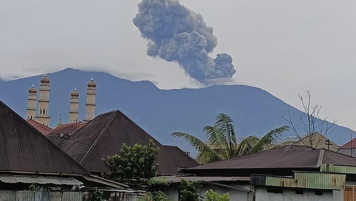
TEMPO.CO, Lumajang - Mount Semeru in East Java experienced a series of ten eruptions on Thursday, January 2, 2025. The resulting ash column reached a height of 1,200 meters above the summit or 4,876 meters above sea level.
Liswanto, an officer at the Semeru Volcano Observation Post (PGA) in Lumajang, reported that the ash column was observed to be white to gray in color, with a moderate intensity directed towards the north.
Seismograph recordings from the monitoring post located on Mount Sawur in Sumber Wuluh Village, Candipuro District, Lumajang Regency, East Java, documented ten eruptions from early Thursday morning through the afternoon.
The most intense volcanic activity occurred at 00:57, 02:41, 05:05, 07:57, 08:51, 10:02, 11:18, 11:22, 11:25, and 11:37. The peak intensity was monitored between 11:00 and 12:00, during which Semeru erupted four times within approximately one hour. However, visual observation of the eruptions was hampered by thick cloud cover.
Liswanto confirmed that Mount Semeru's activity level remains at Alert Level II (Waspada). The Mount Semeru monitoring post also recorded various seismic activity in the 24 hours leading up to early Thursday morning.
This included 34 eruption earthquakes with amplitudes ranging from 10-23 mm and durations of 53-145 seconds; one avalanche earthquake with an amplitude of 3 mm and a duration of 50 seconds; seven "gust" earthquakes with amplitudes of 2-8 mm and durations of 34-62 seconds; three distant tectonic earthquakes with amplitudes of 9-20 mm, S-P waves of 22-26 seconds, and durations of 52-86 seconds; and one flood vibration earthquake with an amplitude of 10 mm and a duration of 4,950 seconds.
Given Mount Semeru's current Level II (Alert) status, the Center for Volcanology and Geological Disaster Mitigation (PVMBG) has issued several recommendations to local residents. These include avoiding all activity within an 8 km radius of the peak (eruption epicenter) in the southeast sector along Besuk Kobokan.
Outside of this 8 km radius, the public is advised to refrain from any activity within 500 meters of riverbanks along Besuk Kobokan due to the potential for hot clouds and lava flows extending up to 13 km from the peak.
The PVMBG also urges residents to avoid any activity within a 3 km radius of the crater or peak of Mount Semeru due to the risk of ejected incandescent rocks. Furthermore, the public is urged to remain vigilant regarding the potential for hot clouds, lava avalanches, and lava flows along rivers or valleys originating from the mountain's peak, particularly along Besuk Kobokan, Besuk Bang, Besuk Kembar, and Besuk Sat, as well as the potential for lava flows in smaller rivers that are tributaries of Besuk Kobokan.
Editor's Choice: Prabowo's Statement on Palm Oil May Threaten the Environment, Satya Bumi Says
Click here to get the latest news updates from Tempo on Google News
Mount Semeru in East Java Erupts, No Visual Eruption Observed
1 hari lalu

East Java volcano, Mount Semeru, erupted on Tuesday night, December 31, 2024, at 20:24 Western Indonesia Time.
Mount Semeru Hiking Route Reopens with Restrictions
1 hari lalu

The official announcement of Mount Semeru's hiking route reopening was made on Dec. 23, 2024, by Minister of Forestry Raja Juli Antoni.
The Impact of Indonesia's Mount Dukono Eruption in North Halmahera
3 hari lalu

The eruption of Mount Dukono on Thursday, December 26, 2024 was recorded as many as 406 eruptions from 00:00 to 23:59 WIT (Eastern Indonesia Time).
Mount Ibu Erupts, Spewing Volcanic Ash as High as 1,500 Meters
7 hari lalu

Mount Ibu erupted again by spewing volcanic ash as high as 1,500 meters above the peak of the mountain on Wednesday, December 25, 2024.
Mount Semeru Erupts With 2 Kilometers of Hot Clouds to Besuk Kobokan
7 hari lalu

Mount Semeru reportedly erupted accompanied by a 2-kilometer hot cloud ejection heading towards Besuk Kobokan, Wednesday, December 25, 2024.
KAI Jember Serves 20,000 Passengers Amid Mount Raung Eruption
8 hari lalu

The eruption of Mount Raung did not have much impact on the operation of KAI in Daop 9 Jember.
Natural Disasters 2024, BNPB: 5.6 Million People Displaced, 469 Dead, 58 Still Missing
10 hari lalu

More than 5.64 million people have been victims of natural disasters in various regions in Indonesia throughout this year, from January 1 to Dec. 22.
Mount Dieng Raised to Alert Status Following Eruption; Toxic Gas Risk Reported in Several Craters
12 hari lalu

The Geological Agency has elevated the activity status of Mount Dieng in Wonosobo Regency, Central Java, from Normal to Alert.
Indonesian Geological Agency Records Increase in Seismic Activity from Mount Raung
15 hari lalu

Indonesian Geological Agency says the seismic activity of Mount Raung is still being monitored to be increasing.
Mount Semeru Spews Volcanic Ash to a Height of 1,000 Meters This Morning
16 hari lalu

Mount Semeru in East Java reportedly erupted again. The eruption column was observed to be approximately 1,000 meters above the peak.