February 5, 2025 | 11:58 pm

TEMPO.CO, Jakarta - Hundreds more people were expected to leave Greece's Santorini island on Wednesday as tremors shook the popular summer tourist destination for a sixth day.
About 10,000 people have left on ferries and planes in recent days as hundreds of small quakes were registered in the surrounding sea, shaking buildings, kicking up dust on the island's rocky cliffs, and raising fears of a major earthquake.
The island's population swells in summer when millions of tourists visit the traditional white-painted villas that line its steep hillsides. The 2021 census puts Santorini's permanent population at 15,000, so it is likely that a few thousand remain on the island, given that it is off-season.
Authorities have introduced safety measures, including halting construction, shutting schools on Santorini and the nearby islands of Ios, Amorgos and Anafi, and ordering residents and hotels to empty their pools to reduce the burden on the ground.
Government officials and seismologists who met on Wednesday to assess the situation pointed to a high risk of landslides, including near the island's main port Athinios which serves some 1.5 million passengers a year.
Local authorities have restricted access to some high-risk areas, while first responders, vessels and a helicopter were on alert in case of emergency.
"The whole state mechanism has been activated...so that we are ready for any possibility with the hope that things will get better and the phenomenon will decrease in intensity," Greek Prime Minister Kyriakos Mitsotakis said on Wednesday.
Two ferry routes from the port of Piraeus to Santorini and vice versa were canceled on Wednesday due to rough seas. Bad weather was not expected to disrupt six Aegean Airlines flights, including two emergency ones, scheduled for Wednesday.
Seismologists estimate that the high seismic activity could take days or weeks to abate, although locals and government officials said the shaking had lessened on Wednesday.
"It has not shaken much today, I haven't felt anything since 0400 (0200GMT)," said Nikos Sakorafos, owner of a travel agency in the popular tourist village of Fira.
"Now, it's a dead season for the island, most people don't have work so it's easier for them to leave."
Greece is one of the most earthquake-prone countries in Europe as it sits at the boundary of the African and Eurasian tectonic plates whose constant interaction prompts frequent quakes.
Santorini took its current shape following one of the largest volcanic eruptions in history, around 1600 BC. The last eruption in the area occurred in 1950.
REUTERS
Editor’s Choice: BMKG Reports M6.0 Earthquake Strikes North Maluku
Click here to get the latest news updates from Tempo on Google News
BMKG Reports M6.0 Earthquake Strikes North Maluku
7 jam lalu

The Meteorology, Climatology, and Geophysics Agency (BMKG) reported M6.0 earthquake struck the North Maluku region, and was felt in Sofifi and Manado.
BMKG Records M5.0 Earthquake in Jambi Due to Indo-Australian Plate Deformation Activity
2 hari lalu

The Meteorology, Climatology, and Geophysics Agency (BMKG) confirms that the earthquake does not have the potential to cause a tsunami.
BMKG: No Tsunami Expected from M6.2 South Aceh Earthquake, What Signs of Tsunami?
4 hari lalu

BMKG stated that the earthquake that occurred west of South Aceh Regency did not have the potential for a tsunami. Here are the signs of a tsunami according to BMKG.
31 Houses Damaged Due to Earthquake in Sulawesi's East Kolaka
7 hari lalu
An earthquake with a magnitude of 5.1 struck East Kolaka Regency, Southeast Sulawesi, on Wednesday, January 29, 2025, at approximately 11:30 WIB.
A Series of Quakes: M5.1 Earthquake Strikes Indonesia's East Kolaka
7 hari lalu

This event marks the 125th earthquake in a series of tremors that have been occurring in the region since January 24, 2025.
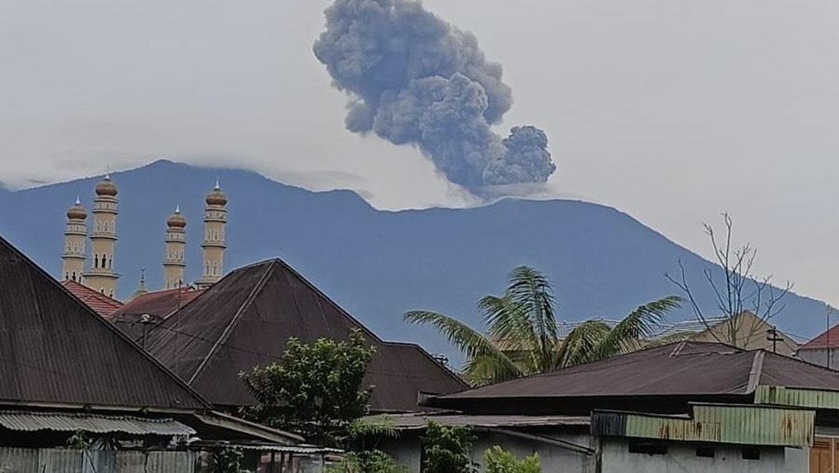
BMKG: M6.1 Earthquake Shakes Central Sulawesi's Palu
8 hari lalu

An earthquake with a magnitude of 6.1 shook Palu, Central Sulawesi, and its surrounding regions on Tuesday night.
M5.8 Earthquake Shakes Philippines' Panaon Island, BMKG: No Tsunami Threats
13 hari lalu
BMKG recorded a tectonic earthquake with a magnitude of 5.8 in Liloan, Panaon Island, Philippines, Thursday, January 23, 2025.
TasteAtlas' 10 Best Salads in the World, Indonesia's Pecel Included
20 hari lalu

Combining nourishing essentials and mouthwatering sauces, these best salads in the world take pride in bringing their country's distinctive cultures.
BMKG on Recent Earthquake in Garut and South Aceh
20 hari lalu
Info on the latest earthquakes that can be felt in Garut and South Aceh according to BMKG.
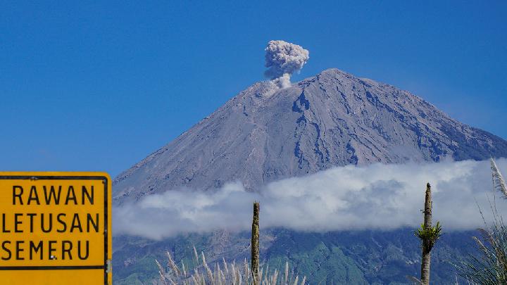
Mount Semeru Erupts, Spews 900 Meters High Ash Column
21 hari lalu

Mount Semeru continues to erupt overnight into Wednesday morning, January 15, at around 7:06 a.m. local time.