TEMPO.CO, Jakarta - The evacuation and recovery efforts for the ATR 42-500 aircraft, which reportedly crashed in the Bantimurung Bulusaraung National Park in South Sulawesi, Indonesia, are ongoing under the coordination of the joint Search and Rescue (SAR) team.
On Sunday morning, January 18, 2026, debris from the aircraft was discovered on the southern slope of Mount Bulusaraung, while the fuselage was located on the northern side of the peak.
The plane had lost contact while approaching Sultan Hasanuddin Airport in Makassar on Saturday, January 17, 2026.
The crash site and its surrounding environment have several unique characteristics that make Mount Bulusaraung both a challenging location for rescue operations and an ecologically significant area.
Here’s what you need to know about the mountain and the ATR 42-500 crash site:
Mount Bulusaraung: A Sulawesi Karst Icon
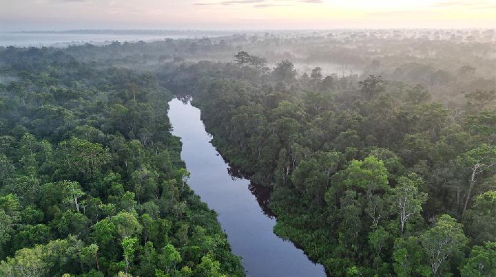
Mount Bulusaraung, rising approximately 1,353 meters above sea level, is a prominent peak in South Sulawesi and forms part of the Maros-Pangkep karst region.
Located within Bantimurung Bulusaraung National Park, the mountain is known for its steep terrain, limestone formations of the Tonasa Formation, and areas of andesite lithology resulting from intrusive igneous activity.
Abdul Rajab, head of Bantimurung Bulusaraung National Park, described the peak as a typical karst landscape, characterized by steep cliffs, sharp rocks, caves, and persistent mist that blankets the area even during the dry season.
The combination of high humidity, temperature fluctuations, and dense forest vegetation creates a unique microclimate, making the summit unsuitable for camping.
Climbing Routes and Safety Measures
Despite its challenging terrain, Mount Bulusaraung is a popular destination for climbers in South Sulawesi. The mountain features nine designated resting posts, with Post 9 serving as the official camping area equipped with shelters and clean water.
From Post 9, climbers can reach the summit in approximately 30 minutes.
The National Park Office enforces strict regulations to ensure visitor safety, including prohibiting overnight stays at the peak due to strong winds and thick mist.
Seasonal weather patterns also affect climbing conditions: from October to February, heavy rainfall and strong winds make outdoor activities risky, while the dry season from July to September is the busiest period for climbers.
The park office monitors weather reports and issues warnings based on data from Indonesia’s Meteorology, Climatology, and Geophysics Agency (BMKG).
Dynamic Weather and Seasonal Risks
Weather conditions on Mount Bulusaraung are heavily influenced by seasonal climatic patterns. Between October and February, outdoor activities are considered risky due to high rainfall, which can last for up to three consecutive days and is often accompanied by strong winds.
The dry season, from July to September, sees the highest climbing activity.
To ensure visitor safety, theBantimurung Bulusaraung National Park Office applies an open-close climbing route system based on weather data and warnings issued by Indonesia’s Meteorology, Climatology, and Geophysics Agency (BMKG).
Extreme weather alerts are periodically announced through official BMKG channels.
Rich Biodiversity and Endemic Wildlife
Beyond its steep and rugged terrain, Mount Bulusaraung holds significant ecological value. The dense forest supports a rich variety of vegetation that provides critical habitat for endemic fauna of Sulawesi.
Among the most notable plants are 43 species of Ficus, which serve as essential food sources for wildlife.
The mountain is home to endemic species such as the Sulawesi Hanging Parrot, Bear Cuscus, Tarsier, and Sulawesi Black Macaque.
Additionally, the Sulawesi Palm Civet, a species rare elsewhere, has been documented in the area using camera traps.
This finding indicates that the ecosystem of Mount Bulusaraung remains largely intact and continues to function as a healthy natural habitat.
The ongoing SAR operation to evacuate the ATR 42-500 crash site highlights the challenges of aviation in such steep and mist-prone terrain while underscoring the ecological importance of Mount Bulusaraung’s karst forests.
Read: List of Plane Crashes Across Indonesia in Last Five Years
Click here to get the latest news updates from Tempo on Google News