November 28, 2025 | 06:44 am
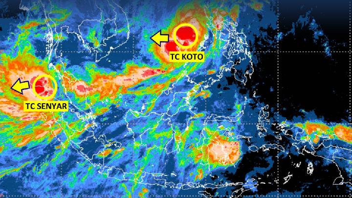
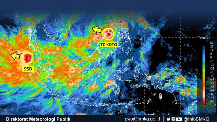
TEMPO.CO, Jakarta - Unlike Tropical Cyclone Senyar, whose maximum sustained winds have weakened, Tropical Cyclone Koto remains a category 3 until Friday morning, November 28, 2025. The cyclone initially formed as Seed Cyclone 92W and is currently circulating in the West Philippine Sea. It has maximum sustained winds of 75 knots (139 km/h) and a minimum central pressure of 965 hPa.
According to the Meteorology, Climatology, and Geophysics Agency (BMKG) observations until yesterday, Thursday, Tropical Cyclone Koto is moving in a west-southwest direction, away from the Indonesian territory. However, this wind vortex continues to trigger moderate to heavy rainfall in the Riau Islands.
Another effect of Tropical Cyclone Koto is high waves measuring 2.5-4 meters in the North Natuna Sea and the waters of the Natuna Islands. The same high sea waves also pose a risk in the waters near the Subi Islands, Serasan, and the northern waters of the Anambas Islands.
BMKG also issued an official statement regarding the latest development of Ex-Tropical Cyclone Senyar, the post-tropical phase of Tropical Cyclone Senyar. The cyclone, whose wind intensity has weakened, was observed around the eastern parts of Aceh.
The maximum speed of Ex-Cyclone Senyar is now about 30 knots (56 km/h), with a minimum pressure of 1,001 hPa. The maximum wind speed of this cyclone is predicted to decrease further on Friday, at which point it will become a tropical depression or low and move eastward.
Despite the maximum wind speed weakening, the remnants of Cyclone Senyar are expected to trigger very heavy to extreme rainfall in Aceh, North Sumatra, and West Sumatra. There is also the effect of high waves in the western Indian Ocean from Aceh to the Nias Islands.
Although Tropical Cyclone Senyar did not impact Jakarta and its surrounding areas, it caused major flooding on the Malaysian Peninsula after forming as Cyclone 95B. Its influence also caused extreme rainfall in northern Sumatra.
Erma Yulihastin, a climate and atmosphere researcher at the National Research and Innovation Agency (BRIN), referred to Senyar as a very rare cyclone event. Astronomically, Langsa is located at 4.5 degrees north of the equator. This fact makes Senyar the second tropical storm after Vamei in December 2001 to defy the "meteorological law" by forming near the equator.
At that time, Typhoon Vamei formed even closer to the equator, at 1.3 degrees north latitude. Specifically, only 150 kilometers from the equator line in the South China Sea, near Singapore. This means that Senyar is the second southernmost landfalling tropical storm recorded in the Northern Hemisphere, after Vamei.
Zacharias Wuragil contributed to this article
Editor's Choice: BMKG: Jakarta Likely to Remain Cloudy Today
Click here to get the latest news updates from Tempo on Google News
BMKG: Jakarta Likely to Remain Cloudy Today
29 menit lalu

A light-intensity rain is predicted, but it will only affect a few areas in Jakarta's satellite cities.
Tracking Tropical Cyclone Senyar's Path After Making Landfall in Aceh
20 jam lalu
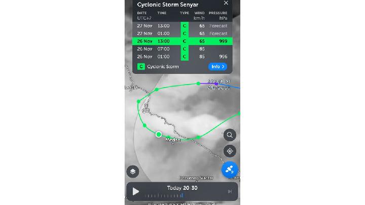
Tropical Cyclone Senyar is predicted to have re-entered the waters of the Malacca Strait, east of Aceh, today on Thursday, November 27, 2025.
Jakarta Remains Cloudy Amid Tropical Cyclones
22 jam lalu

While Tropical Cyclones Senyar and Koto are affecting the northern parts of Indonesia, what about the weather in Jakarta and the surrounding areas?
Extreme Weather Brews as Two Tropical Cyclones Surround Indonesia
1 hari lalu
BMKG detected two tropical cyclones affecting the weather in Indonesia, namely Tropical Cyclone Koto and Tropical Cyclone Senyar.
Today's Top 3 News: Cyclone 95B Behind Malaysia Floods Expected to Make Landfall in Sumatra
1 hari lalu

Here is the list of the top 3 news on Tempo English today.
Two Cyclone Seeds Trigger High Waves and Powerful Winds in the Nias Islands
1 hari lalu

BMKG reminds mariners of the effects of cyclone 95B and 92W winds. The latest high wave early warning is valid from 26-29 November 2025.
BMKG Warns: Tropical Cyclone 95B Could Bring Extreme Weather to Aceh, North Sumatra, West Sumatra and Riau
1 hari lalu
Tropical Cyclone 95B triggers the potential of extreme weather including heavy to extreme rain and strong winds, according to the BMKG.
Cyclone 95B Behind Malaysia Floods Expected to Make Landfall in Sumatra
2 hari lalu
A BRIN researcher said that if Tropical Cyclone 95B does make landfall in Sumatra, the impact of its strong winds will be tremendously destructive.
Cyclone Fina Batters Australia's Northern Territory
3 hari lalu
A tropical cyclone hit Australia's Northern Territory overnight, uprooting trees, traffic lights & severing power for thousands of people in its wake.
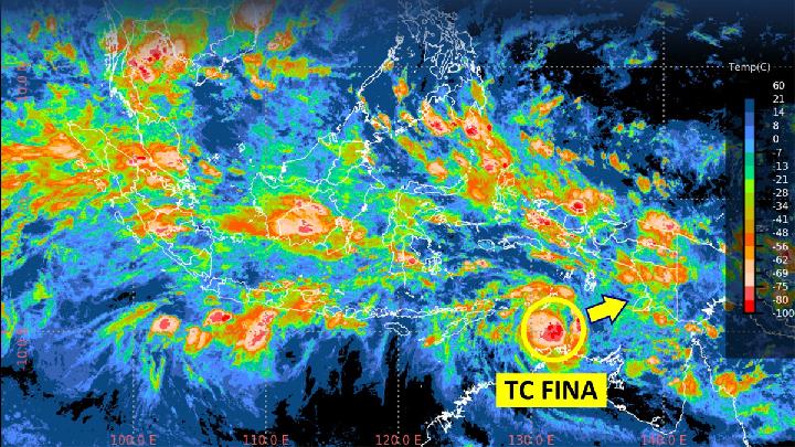
Tropical Cyclone FINA Stirs Arafuru Sea, Triggers High Waves
7 hari lalu
BMKG issues a warning about the high waves of 4 meters in several zones due to the wind effects of tropical cyclone Fina located in the Arafuru Sea.